Underwater survey services from DiveRobotix provide professional ROV-based lake monitoring, deep-water inspection, and scientific data collection. Underwater survey services include bathymetric mapping, infrastructure assessment, and environmental monitoring to 500-meter depths. DiveRobotix underwater survey services deliver research-grade documentation for universities, government agencies, and commercial clients nationwide.
Professional ROV Lake Monitoring & Deep-Water Inspection
500m depth capability | 4K documentation | Scientific-grade data | University & government proven | Nationwide travel
Call (775) 230-1116
Request Survey Proposal
17+
Years Professional Experience
500m
ROV Depth Rating
4K
Video Documentation
3mi
Single-Day Survey Capability
Underwater Survey Services: Professional ROV Solutions
When diver-based surveys are too expensive, too risky, or impossible due to depth or conditions, underwater survey services from DiveRobotix deliver professional-grade data collection using advanced ROV technology.
🎯 Why Choose ROV-Based Services?
Safety: No diver exposure to cold water, contamination, or depth hazards. ROV operations eliminate human risk while maintaining data quality.
Efficiency: Survey 3+ miles in a day. Professional ROV services cover more area faster than diver teams at lower cost.
Depth Access: Work to 500 meters where divers cannot reach. ROV technology accesses deep-water zones safely and economically.
Documentation: 4K video, GPS-tagged data, permanent record. Research-grade documentation with professional standards.
Underwater Survey Services: Core Capabilities
📊
Underwater Survey Services: Lake Monitoring
- Long-term environmental monitoring programs
- Water quality parameter measurement
- Benthic habitat assessment
- Aquatic vegetation surveys
- Temperature/DO/pH profiling
- Seasonal change documentation
- Multi-year comparison studies
Research-grade underwater survey services for scientific monitoring
🗺️
Underwater Survey Services: Bathymetric Mapping
- High-resolution depth mapping
- Sonar-based bottom profiling
- Sediment accumulation measurement
- Volume calculations for dredging
- Navigation hazard identification
- Pre/post-construction surveys
- GIS-compatible data delivery
Professional underwater survey services for engineering projects
🏗️
Underwater Survey Services: Infrastructure Inspection
- Dam structural assessment
- Bridge pier/foundation inspection
- Pipeline and cable surveys
- Water intake inspection
- Spillway condition assessment
- Corrosion and crack detection
- Concrete degradation documentation
Certified underwater survey services for critical infrastructure
🔬
Underwater Survey Services: Scientific Research
- Aquatic invasive species detection (AIS)
- eDNA sample collection
- Benthic organism surveys
- Fish habitat characterization
- Climate change impact studies
- Water column profiling
- Sediment core sampling
University-proven underwater survey services for research
🌊
Underwater Survey Services: Deep-Water Operations
- 500-meter depth-rated ROV capability
- Deep-lake thermocline studies
- Deepwater habitat documentation
- Subsurface structure inspection
- Deep sediment sampling
- Extreme depth debris recovery
- Benthic zone characterization
Advanced underwater survey services for deep-water access
📹
Underwater Survey Services: Video Documentation
- 4K high-definition video capture
- Real-time surface monitoring
- GPS-tagged survey routes
- Time-stamped documentation
- Still photography extraction
- Annotated video reports
- Multi-year comparison footage
Professional underwater survey services with complete documentation
Underwater Survey Services: Client Types
🎓 Universities & Research Institutions
- Multi-year lake monitoring contracts
- Climate change impact studies
- Aquatic ecology research
- Limnology field studies
- Graduate student research support
- Publication-quality data collection
- Grant-funded research projects
Professional underwater survey services supporting academic research nationwide.
🏛️ Government Agencies
- State environmental agencies (DEP, DNR)
- Federal research (USGS, EPA, NOAA)
- Regional planning authorities
- State park systems
- Water resource management
- Long-term monitoring programs
- Regulatory compliance surveys
Government-proven services with regulatory acceptance.
🏗️ Engineering & Construction
- Pre-construction site assessment
- Dam safety inspection programs
- Bridge foundation surveys
- Marina development planning
- Dredging volume calculations
- As-built verification surveys
- Environmental impact assessments
Engineering-grade services for infrastructure projects.
🌱 Environmental Consultants
- Wetland mitigation monitoring
- Restoration project assessment
- Contamination site surveys
- Habitat compensation verification
- Environmental compliance monitoring
- Baseline condition documentation
- Impact assessment studies
Consultant-ready services with professional reporting.
Underwater Survey Services: Proven Experience
🏛️ TRPA Partnership
Ongoing multi-year contract with Tahoe Regional Planning Agency for Lake Tahoe aquatic invasive species monitoring and environmental surveys. Demonstrates proven capability delivering research-grade services to government agencies with rigorous scientific standards and regulatory requirements.
🚀 NASA Collaboration
Worked with NASA on Micro Submersible Lake Exploration Device (MSLED) and Tahoe Drifter autonomous underwater vehicle development. First deep ROV to capture high-definition video from West Antarctica under the ice. Advanced underwater robotics expertise applicable to extreme environment operations.
⚖️ Legal Evidence Standards
Provided critical evidence for lawsuit regarding 10-mile abandoned AT&T fiber optic cable. Meticulous 4K ROV video documentation combined with comprehensive water sampling. Evidence-grade documentation for legal proceedings and regulatory compliance.
📚 Professional Expertise
Founded by Scott Fontecchio, PADI Master Instructor, ROV engineer, and published author (“Mastering Buoyancy”). 17+ years professional underwater operations including commercial diving, scientific monitoring, and ROV deployment. Over 1,000 successful operations completed.
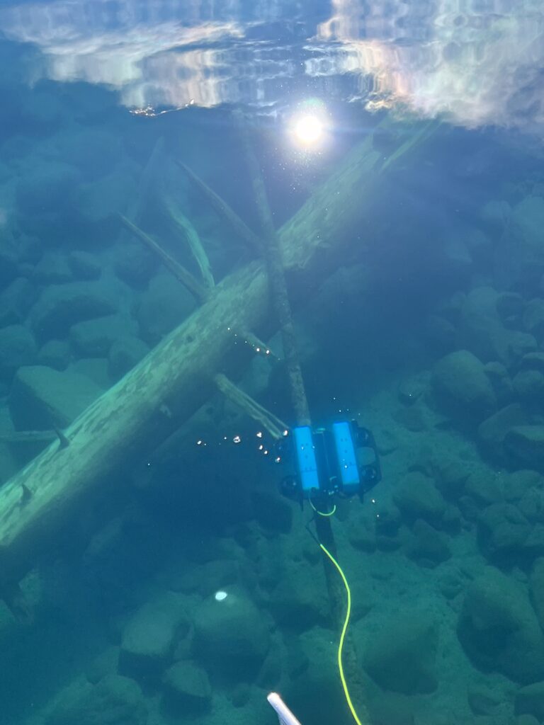
🤖 Underwater Survey Services: Advanced ROV Technology
OEM Shark ROV System
Custom-built 500-meter depth-rated work-class ROV on Blue Robotics heavy platform. Professional equipment includes 4K camera system, dual manipulator arms for sample collection, DVL navigation for autonomous survey capability, sonar integration for bathymetric mapping, and LISST particle analysis systems for scientific monitoring.
Scientific Instrumentation
Comprehensive sensor packages: conductivity/temperature/depth (CTD) profilers, dissolved oxygen sensors, pH measurement, fluorometers for chlorophyll detection, turbidity sensors, eDNA sampling capability, sediment core sampling, and GPS-tagged data collection for GIS integration.
Documentation Standards
Research-grade documentation: 4K HD video recording, high-resolution still photography, GPS-tagged survey routes, time-stamped data logging, real-time surface monitoring, chain of custody protocols, and comprehensive written reports with data analysis and recommendations.
Underwater Survey Services: Why DiveRobotix?
✅
Research-Grade Quality
University and government agency proven. TRPA multi-year contract demonstrates consistent professional delivery. NASA collaboration validates advanced technical capability. Publication-quality data collection and documentation.
⚡
Efficiency & Coverage
ROV-based operations cover 3+ miles per day. Professional efficiency reduces project costs compared to diver-based surveys. Rapid deployment and data collection minimizes field time and client expense.
🌊
Deep-Water Access
500-meter depth-rated ROV where divers cannot reach. Access deep lakes, reservoirs, and extreme depth zones safely. No human risk exposure for deep-water data collection.
✈️
Nationwide Travel
Professional services available anywhere in the United States. Self-contained equipment transport. No need for local ROV infrastructure. Rapid deployment to your survey site.
📊
Comprehensive Reporting
Detailed written reports with maps, data analysis, and recommendations. Grant application support. Regulatory compliance documentation. GIS-compatible data delivery.
🎓
Scientific Credibility
17+ years professional experience. Government agency contracts. University partnerships. Published expertise. Scientifically defensible methodology accepted by regulatory agencies and peer-reviewed research.
💰 Underwater Survey Services: Funding & Contracts
Professional underwater survey services are eligible expenses under most research grants, environmental monitoring contracts, and infrastructure inspection programs.
Common Funding Sources:
- University research grants: NSF, NOAA, EPA research funding
- State agencies: Long-term monitoring contracts (5-year multi-site programs)
- Federal research: USGS, EPA, NOAA scientific studies
- Environmental compliance: Regulatory monitoring requirements
- Infrastructure inspection: Dam safety, bridge inspection budgets
- Environmental consulting: Client-funded impact assessments
Contract Support:
- Detailed scope of work development
- Cost estimates and project budgets
- Methodology documentation for RFPs
- Professional credentials verification
- Insurance and liability documentation
- Deliverables specification
Get Underwater Survey Services for Your Project
Professional ROV-based lake monitoring, deep-water inspection, and scientific data collection. Research-grade quality. Nationwide travel. University & government proven.
(775) 230-1116
Call Now
Request Proposal
500m Depth Capability • 4K Documentation • Scientific-Grade Data • 17+ Years Experience