ATT Abandoned Cable Survey
Autonomous ROV Survey Services
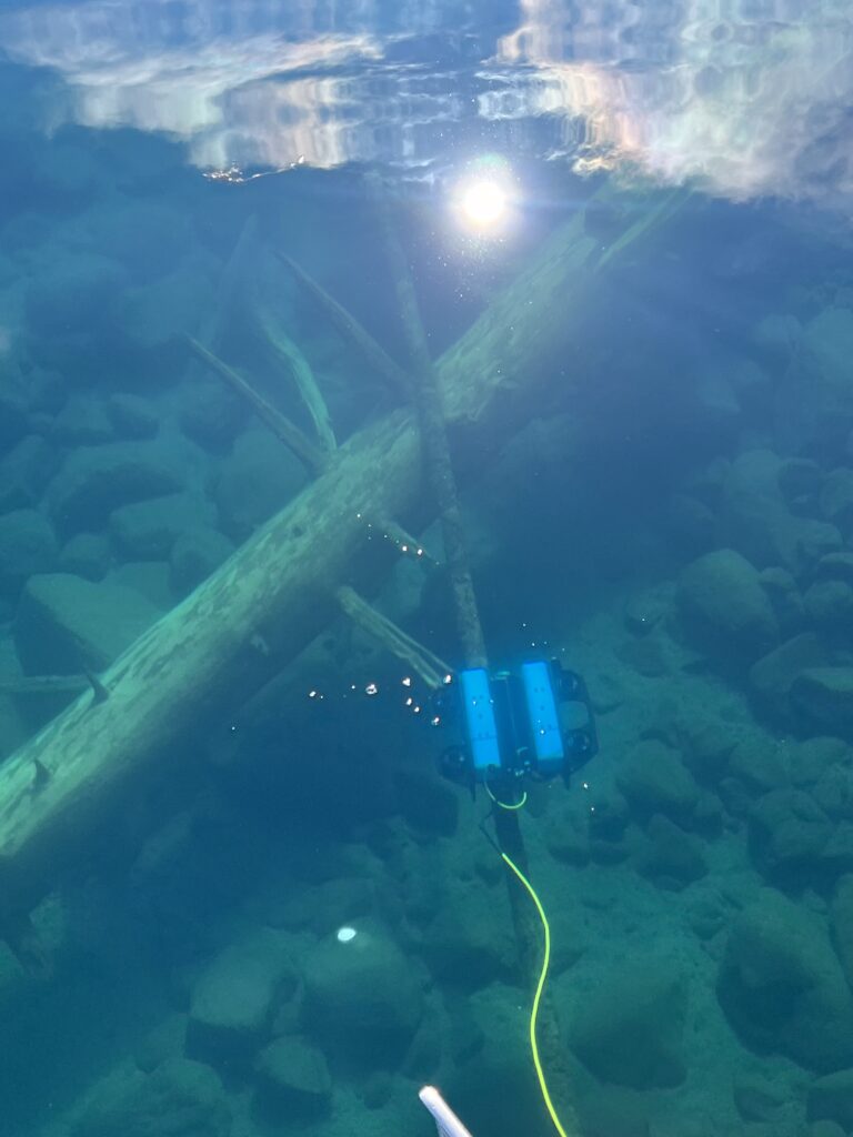
Systematic underwater surveys with DVL-guided “lawn mower” patterns — complete 4K video coverage of large areas with GPS-accurate positioning and zero gaps. No diver notes, no missed zones, just comprehensive documented evidence.
Call (775) 230-1116 Request DemoThe Problem with Traditional Diver Surveys
Manual diver surveys rely on handwritten notes, rough sketches, and human memory. Divers swim transects they estimate visually, record observations on slates, and produce qualitative reports based on what they remember seeing. Coverage is incomplete, documentation is subjective, and repeatability is impossible.
⚠️ What Diver Surveys Miss
Spatial Gaps: Divers can’t see where they’ve been underwater. Navigation is estimated by compass and kick cycles. Large survey areas inevitably have coverage gaps — zones that were never inspected but appear “surveyed” on the final map.
Inconsistent Documentation: Two divers surveying the same site produce different results. One diver’s “heavy colonization” is another’s “moderate coverage.” Species counts are estimates. Damage descriptions are qualitative. Locations are approximate.
Limited Coverage: Bottom time, cold water, and nitrogen loading restrict diver survey duration. A diver might cover 1,000–2,000 square meters in a 40-minute dive. Complex sites require multiple dives over multiple days — expensive and weather-dependent.
Autonomous ROV Survey: Complete, Systematic, Documented
🤖 DVL-Guided Navigation = Zero Gaps
Our custom ROVs use Doppler Velocity Log (DVL) technology to maintain precise position relative to the lakebed — accurate to ±10 centimeters. The ROV autonomously flies pre-programmed “lawn mower” patterns with controllable overlap, ensuring every square meter of the survey area is captured on 4K video.
The ROV emits acoustic beams to the bottom, measures the Doppler shift in returning sound, and calculates precise velocity and position. Unlike GPS (which doesn’t work underwater) or visual navigation (which fails in turbidity), DVL provides centimeter-level positioning regardless of water clarity.
We program survey grid parameters — altitude above bottom, speed, transect spacing, overlap percentage. The ROV executes the pattern autonomously while streaming live 4K video. Operators monitor in real-time but don’t manually pilot — the system guarantees complete coverage.
Systematic Coverage Patterns
- Parallel transects: Standard lawn mower with 10–50% overlap
- Grid patterns: Orthogonal passes for maximum detail
- Radial surveys: Circular patterns from central points
- Custom geometry: Irregular boundaries, obstacle avoidance
- Multi-altitude passes: Wide overview + low-altitude detail
Complete Video Documentation
- 4K HD video of entire survey area
- GPS coordinates embedded in video metadata
- Timestamped and geo-referenced frames
- Live streaming for real-time QA/QC
- Permanent archival record
- Frame-by-frame analysis capability
Autonomous ROV vs Manual Diver Survey
| Factor | Autonomous ROV Survey | Traditional Diver Survey |
|---|---|---|
| Coverage Completeness | 100% — DVL-guided patterns guarantee no gaps | Estimated 60–80% — gaps are inevitable in large areas |
| Position Accuracy | ±10cm with DVL navigation | ±5–10m with compass and kick cycles |
| Documentation Quality | 4K video of every square meter, GPS-tagged | Handwritten notes, rough sketches, memory-based reports |
| Survey Duration | Unlimited — no decompression, no nitrogen loading | 40–60 minutes per dive, multi-dive/multi-day for large sites |
| Area Coverage Rate | 5,000–10,000 m²/hour depending on altitude and speed | 500–1,000 m²/dive (40 min bottom time) |
| Depth Capability | 0–500 feet, no depth restrictions | 0–130 feet practical limit (recreational/commercial diving) |
| Turbidity Performance | DVL navigation works in zero visibility | Diver navigation fails in poor visibility |
| Repeatability | Perfect — same pattern executable years later for comparison | Impossible — no two diver surveys follow identical paths |
| Weather Dependency | Moderate — ROV can work in chop that grounds divers | High — divers require calm conditions for safety |
| Data Analysis | Permanent video record allows unlimited post-survey review | Analysis limited to diver’s in-water observations and notes |
Applications for Autonomous ROV Surveys
AIS Baseline & Monitoring
Establish comprehensive baseline documentation of reservoir or lake substrate conditions before invasive species arrive. Repeat identical survey patterns annually to detect early colonization across the entire waterbody.
- Large-area dreissenid mussel surveys
- Aquatic plant distribution mapping
- Year-over-year comparison surveys
- Early detection rapid response verification
Infrastructure Condition Assessment
Document the complete condition of underwater infrastructure — dam faces, intake structures, pier pilings, seawalls — with 4K video evidence that supports engineering analysis and regulatory compliance.
- Dam safety inspection surveys
- Water intake pipe assessment
- Bridge pier and piling surveys
- Underwater cable and pipeline inspection
Environmental Monitoring
Systematically document benthic habitats, species distributions, and environmental conditions across large survey areas for NEPA compliance, habitat restoration planning, or long-term ecological monitoring programs.
- Benthic habitat characterization
- Species distribution mapping
- Substrate composition surveys
- Pre/post-construction monitoring
Search & Recovery
Systematically search large areas for lost equipment, sunken vessels, or underwater debris with guaranteed coverage. Perfect for post-event surveys where target location is unknown but general area is defined.
- Sunken vessel location
- Lost equipment search
- Post-storm debris surveys
- Archaeological site documentation
What You Receive
📦 Standard Survey Deliverables
- Complete 4K Video: Entire survey from start to finish with GPS metadata
- Survey Coverage Map: GIS-compatible shapefile showing exact ROV track
- Key Frame Stills: High-resolution images of notable observations
- Written Report: Survey objectives, methods, findings, recommendations
- Observation Log: Timestamped list of species, conditions, anomalies
- GPS Coordinates: Location data for all documented features
- Raw Data Files: Unprocessed video and navigation data for client analysis
- Comparison Analysis: Multi-year change detection (repeat surveys)
💡 Custom Analysis Available
We can perform post-survey video analysis tailored to your objectives — species counts, colonization density mapping, damage quantification, habitat classification, substrate composition percentages, or any other metrics extractable from systematic video coverage. Analysis pricing depends on survey area and complexity.
Why Agencies Choose Our Autonomous ROV Surveys
🔧 Custom-Built ROVs
We design and manufacture our own ROV systems optimized for freshwater survey work. DVL navigation, 4K cameras, extended endurance, and mission-specific sensor integration. Not off-the-shelf consumer drones.
📊 Defensible Data
Systematic coverage with GPS-accurate positioning produces data that withstands regulatory scrutiny. Perfect for NEPA documentation, permit applications, litigation support, or long-term monitoring programs requiring rigorous methodology.
⏱️ Time & Cost Efficiency
Survey 10,000 m² in one day instead of a week of diver operations. No decompression delays, no weather holds, no multi-day mobilization. Lower total cost for large-area surveys despite advanced technology.
Ready for Complete Survey Coverage?
Autonomous ROV surveys deliver systematic documentation that diver-based methods can’t match. Let’s discuss your project.
(775) 230-1116Call or email Scott at DiveRobotix
Call Now Request Technical Brief